Land use/land cover change assessment of Mohana watershed (Far-Western Nepal) using GIS and remote sensing
DOI:
https://doi.org/10.26832/24566632.2021.060309Keywords:
Change matrix, GIS and Remote sensing, Landsat, LULC, WatershedAbstract
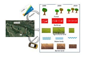
The present study was conducted in the Mohana watershed of Far-western Nepal to assess land use land cover change. The study has used ArcGIS and three Landsat images - Landsat TM (1999), Landsat ETM+ (2009), and Landsat OLI (2019) – to analyze land use the land cover change of the watershed. The change matrix technique was used for change detection analysis. The study area was classified into five classes; forest, agriculture, built-up, water bodies, and barren lands. The study has found that among the five identified classes forest and build-up increased positively from 45.40 % to 51.51 % - forest cover and 11.26 % to 19. 85 % - build-up respectively. Similarly, agricultural land and water bodies initially increased but after 2009 both land cover areas decreased to 23.79 % and 0.73 % from 31.38 % and 0.97 % in 2009 respectively. Barren land decreased from 15.37% to 4.12% over the last 20 years. This study might support land-use planners and policymakers to adopt the best suitable land use management option for the Mohana watershed.
Downloads
References
Attri, P., Chaudhry, S., & Sharma, S. (2015). Remote sensing & GIS based approaches for LULC change detection–a review. International Journal of Current Engineering and Technology, 5(5), 3126-3137.
Awasthi, K. D., Sitaula, B. K., Singh, B. R., & Bajacharaya, R. M. (2002). Land use change in two Nepalese watersheds: GIS and geomorphometric analysis. Land Degradation & Development, 13(6), 495-513.
Bajjali, W. (2018). Watershed delineation. In ArcGIS for environmental and water issues (pp. 235-245). Springer, Cham.
Bharatkar, P. S., & Patel, R. (2013). Approach to accuracy assessment tor RS image classification techniques. International Journal of Scientific & Engineering Research, 4(12), 79-86.
Bhawana, K. C., Wang, T., & Gentle, P. (2017). Internal migration and land use and land cover changes in the middle mountains of Nepal. Mountain research and development, 37(4), 446-455.
CBS (2014) Population Monograph of Nepal. Kathmandu. Central Bureau of Statistics.
Chaulagain, D., & Rimal, P. R. (2019). Coping Mechanisms of Local People to Mitigate Climate Change Impacts on Water Resources in Kailali District-Nepal. International Journal of Scientific Technology & Research, 8(4), 117-121.
Chowdhury, M., Hasan, M. E., & Abdullah-Al-Mamun, M. M. (2020). Land use/land cover change assessment of Halda watershed using remote sensing and GIS. The Egyptian Journal of Remote Sensing and Space Science, 23(1), 63-75.
Dinka, M. O., & Chaka, D. D. (2019). Analysis of land use/land cover change in Adei watershed, Central Highlands of Ethiopia. Journal of Water and Land Development.
Gautam, A. P., Webb, E. L., & Eiumnoh, A. (2002). GIS assessment of land use/land cover changes associated with community forestry implementation in the Middle Hills of Nepal. Mountain Research and Development, 22(1), 63-69.
Haque, M. I., & Basak, R. (2017). Land cover change detection using GIS and remote sensing techniques: A spatio-temporal study on Tanguar Haor, Sunamganj, Bangladesh. The Egyptian Journal of Remote Sensing and Space Science, 20(2), 251-263.
Ishtiaque, A., Shrestha, M., & Chhetri, N. (2017). Rapid urban growth in the Kathmandu Valley, Nepal: Monitoring land use land cover dynamics of a himalayan city with landsat imageries. Environments, 4(4), 72.
Lu, D., Mausel, P., Brondizio, E., & Moran, E. (2004). Change detection techniques. International journal of remote sensing, 25(12), 2365-2401.
Maitima, J. M., Olson, J. M., Mugatha, S. M., Mugisha, S., & Mutie, I. T. (2010). Land use changes, impacts and options for sustaining productivity and livelihoods in the basin of lake Victoria. Journal of sustainable development in Africa, 12(3), 1520-5509.
Neupane, D., Gyawali, P., & Tamang, D. (2019). Study of river channel migration and identification of potential sugarcane cultivation area in the mohana-macheli watershed using remote sensing. ISPRS Annals of Photogrammetry, Remote Sensing & Spatial Information Sciences, 4.
Pathak, R. S., & Lamichhane, K. (2014). Population size, growth and distribution. Population monograph of Nepal, Volume II.
Paudyal, K., Baral, H., Bhandari, S. P., Bhandari, A., & Keenan, R. J. (2019). Spatial assessment of the impact of land use and land cover change on supply of ecosystem services in Phewa watershed, Nepal. Ecosystem Services, 36, 100895.
Poertner, E., Junginger, M., & Müller-Böker, U. (2011). Migration in far west Nepal: intergenerational linkages between internal and international migration of rural-to-urban migrants. Critical Asian Studies, 43(1), 23-47.
Rai, R., Zhang, Y., Paudel, B., Li, S., & Khanal, N. R. (2017). A synthesis of studies on land use and land cover dynamics during 1930–2015 in Bangladesh. Sustainability, 9(10), 1866.
Rimal, B., Zhang, L., Stork, N., Sloan, S., & Rijal, S. (2018). Urban expansion occurred at the expense of agricultural lands in the Tarai region of Nepal from 1989 to 2016. Sustainability, 10(5), 1341.
Shalaby, A., & Tateishi, R. (2007). Remote sensing and GIS for mapping and monitoring land cover and land-use changes in the Northwestern coastal zone of Egypt. Applied geography, 27(1), 28-41.
Shrestha, R. P., Pasakhala, B., & Qasim, S. (2019). Assessing household vulnerability to climate variability in far-west Nepal. Journal of Sustainable Development Studies, 12(2).
Shrestha, A. K., & Shah, R. D. T. River Health Assessment of Mohana Watershed, Nepal: Implication for River Conservation.
Turner, B. L., Skole, D., Sanderson, S., Fischer, G., Fresco, L., & Leemans, R. (1995). Land use and land-cover change: science/research plan. [No source information available].
Uddin, K., Shrestha, H. L., Murthy, M. S. R., Bajracharya, B., Shrestha, B., Gilani, H., & Dangol, B. (2015). Development of 2010 national land cover database for the Nepal. Journal of Environmental management, 148, 82-90.
Usman, M., Liedl, R., Shahid, M. A., & Abbas, A. (2015). Land use/land cover classification and its change detection using multi-temporal MODIS NDVI data. Journal of Geographical Sciences, 25(12), 1479-1506.

Downloads
Published
How to Cite
Issue
Section
License
Copyright (c) 2021 Agriculture and Environmental Science Academy

This work is licensed under a Creative Commons Attribution-NonCommercial 4.0 International License.


