Machine learning approach to detect Land Use Land Cover (LULC) change in Chure region of Sarlahi district, Nepal
DOI:
https://doi.org/10.26832/24566632.2023.0802012Keywords:
Change detection, Chure, Land cover, Landsat, Machine learningAbstract
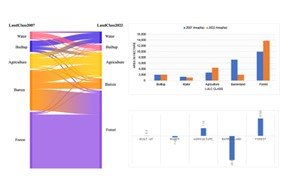
Land Use and Land Cover (LULC) changes are major global environmental issues, affecting ecological systems, climate change, and biodiversity. The Chure region of the Sarlahi district in Nepal is a critical ecological zone that has experienced significant LULC changes in recent years. In this study, our aim was to apply a machine learning approach to detect LULC changes in the Chure region using Google Earth Engine (GEE) and the Random Forest classifier. We utilized Landsat imagery of 2007 and 2022 to generate land cover maps for each year, which were then compared to identify changes over time. The major findings of this study indicate that the forest cover in the region has increased by approximately 16% over the past 15 years, while the agriculture and built-up areas have also shown a significant increase. Conversely, the barren land and water areas have decreased. The classifier obtained an overall accuracy of 85.7% and a kappa coefficient of 81.2% for the year 2022, and an overall accuracy of 82.2% and a kappa coefficient of 76.8% for the year 2007, which demonstrates the high accuracy of the proposed approach. The use of GEE and random forest classifiers provided a cost-effective and efficient method for analysing large datasets and producing accurate LULC maps. Our findings can inform policymakers and conservationists about the need for sustainable land management practices to preserve the ecological integrity of the Chure region. The approach can be applied to other regions to monitor and manage LULC changes and support effective conservation efforts.
Downloads
References
Adhikari, S., Rawal, S., & Thapa, S. (2022). Assessment of status of climate change and determinants of people’s awareness to climate-smart agriculture: A case of Sarlahi district, Nepal. Advances in Agriculture, 2022, 9–15, https://doi.org/10.1155/2022/1556407
Appiah, D. O., Schröder, D., Forkuo, E. K., & Bugri, J. T. (2015). Application of geo-information techniques in land use and land cover change analysis in a peri-urban district of Ghana. ISPRS International Journal of Geo-Information, 4(3), 1265–1289, https://doi.org/10.3390/ijgi4031265
Aulestia, M. J. S. (2019). Understanding land use and land cover dynamics in the Chure region of Nepal: Integrating physiographic, socio-economic and policy
Bashyal, S. (2020). Management of Degraded Chure Hills Through Soil Conservation Practices (a Case Study of Hariwan Municipality-1, Sarlahi District) (Issue September). https://www.researchgate.net/publication/344394241
Bishwokarma, D., Thing, S. J., & Paudel, N. S. (2019). Political Ecology of the Chure Region in Nepal. Journal of Forest and Livelihood, 14(1), 84–96,
https://doi.org/10.3126/jfl.v14i1.23164
Budhathoki, S. (2022). Assessing drivers and dynamics of land use land cover change in churia region of Makwanpur district using GIS and remote sensing. Discovery, 57(September), 608–620.
Crego, R. D., Stabach, J. A., & Connette, G. (2022). Implementation of species distribution models in Google Earth Engine. Diversity and Distributions, 28(5), 904–916, https://doi.org/10.1111/ddi.13491
DFRS. (2014). Churia Forests of Nepal (2011-2013). In Forest Resource Assessment Nepal Project/Department of Forest Research and Survey. (Issue July).
Farr, T. G., Rosen, P. A., Caro, E., Crippen, R., Duren, R., Hensley, S., Kobrick, M., Paller, M., Rodriguez, E., Roth, L., Seal, D., Shaffer, S., Shimada, J., Umland, J., Werner, M., Oskin, M., Burbank, D., & Alsdorf, D. (2007). The Shuttle Radar Topography Mission. Reviews of Geophysics, 45(2). https://doi.org/https://doi.org/10.1029/2005RG000183
Feng, S., Li, W., Xu, J., Liang, T., Ma, X., Wang, W., & Yu, H. (2022). Land use/land cover mapping based on GEE for the monitoring of changes in ecosystem types in the upper Yellow River basin over the Tibetan Plateau. Remote Sensing, 14(21), 1–25, https://doi.org/10.3390/rs14215361
FRTC. (2022). National Land Cover Monitoring System of Nepal. https://frtc.gov.np/uploads/files/3053_GoN_National land cover monitoring system for Nepal - 18 April 2022_WEB.pdf
Gandhi, G. M., Parthiban, S., Thummalu, N., & Christy, A. (2015). NDVI: Vegetation change detection using remote sensing and GIS – A case study of Vellore district. Procedia Computer Science, 57, 1199–1210, https://doi.org/https://doi.org/10.1016/j.procs.2015.07.415
Gislason, P. O., Benediktsson, J. A., & Sveinsson, J. R. (2006). Random forests for land cover classification. Pattern Recognition Letters, 27(4), 294–300.
Gorelick, N., Hancher, M., Dixon, M., Ilyushchenko, S., Thau, D., & Moore, R. (2017). Google Earth Engine: Planetary-scale geospatial analysis for everyone. Remote Sensing of Environment, 202, 18–27, https://doi.org/10.1016/j.rse.2017.06.031
Huete, A. R. (1988). A soil-adjusted vegetation index (SAVI). Remote Sensing of Environment, 25(3), 295–309, https://doi.org/https://doi.org/10.1016/0034-4257(88)90106-X
Liaw, A., & Wiener, M. (2002). Classification and regression by randomForest. R News, 2(3), 18–22.
Maingi, J. K., Marsh, S. E., Kepner, W. G., & Edmonds, C. M. (2002). An Accuracy Assessment of 1992 Landsat-MSS Derived Land Cover for the Upper San Pedro Watershed (U.S./Mexico). 28.
MoEF. (2019). The Environment Protection Act, 2019 ( 2076 ). Ministry of Environment and Forests, Government of Nepal, 2019(9), 1–24.
Paudel, B., Zhang, Y., Li, S., Liu, L., Wu, X., & Khanal, N. R. (2016). Review of studies on land use and land cover change in Nepal. Journal of Mountain Science, 13(4), 643–660, https://doi.org/10.1007/s11629-015-3604-9
Pokhrel, K. P. (2013). Chure forestry conservation and management plan : A case study of Arghakhanchi district , Nepal. Journal of Geography and Regional Planning, 6(5), 172–183, https://doi.org/10.5897/JGRP12.088
Portnov, B. A., Adhikari, M., & Schwartz, M. (2007). Urban Growth in Nepal: Does Location Matter? Urban Studies, 44, 915–937.
Prabaharan, S., Srinivasa Raju, K., Lakshumanan, C., & Ramalingam, M. (2010). Remote Sensing and GIS Applications on Change Detection Study in Coastal Zone Using Multi Temporal Satellite Data. International Journal of Geomatics and Geosciences, 1(2), 159–166.
Rasul, A., Balzter, H., Ibrahim, G. R. F., Hameed, H. M., Wheeler, J., Adamu, B., Ibrahim, S., & Najmaddin, P. M. (2018). Applying built-up and bare-soil indices from Landsat 8 to cities in dry climates. Land, 7(3). https://doi.org/10.3390/land7030081
Rodriguez-Galiano, V. F., Ghimire, B., Rogan, J., Chica-Olmo, M., & Rigol-Sanchez, J. P. (2012). An assessment of the effectiveness of a random forest classifier for land-cover classification. ISPRS Journal of Photogrammetry and Remote Sensing, 67, 93–104, https://doi.org/https://doi.org/10.1016/j.isprsjprs.2011.11.002
Sawtee. (2016). A Study of Effect of Chure Degradation on Water: A Case of Kamala Basin in Nepal. South Asia Watch on Trade, Economics and Environment (SAWTEE), Briefing Paper No. 19. 19.
Singh, B. K. (2010). Assessment of the upstream Churia Hills and downstream Terai plains linkage: An environmental services perspective. Banko Janakari, 20(1), 17–23.
Singh, B. K. (2017). Land tenure and conservation in Chure. Journal of Forest and Livelihood, 15(1), 87–102, https://doi.org/10.3126/jfl.v15i1.23092
Singh, K. V., Setia, R., Sahoo, S., Prasad, A., & Pateriya, B. (2015). Evaluation of NDWI and MNDWI for assessment of waterlogging by integrating digital elevation model and groundwater level. Geocarto International, 30(6), 650–661, https://doi.org/10.1080/10106049.2014.965757
Tomar, V., Kumar, P., Rani, M., Gupta, G., & Singh, J. (2013). A satellite-based biodiversity dynamics capability in tropical forest. Electronic Journal of Geotechnical Engineering, 18 F(October), 1171–1180.
Vizzari, M. (2022). PlanetScope, Sentinel-2, and Sentinel-1 Data Integration for Object-Based Land Cover Classification in Google Earth Engine. Remote Sensing, 14(11), https://doi.org/10.3390/rs14112628
Wang, S. W., Gebru, B. M., Lamchin, M., Kayastha, R. B., & Lee, W. K. (2020). Land use and land cover change detection and prediction in the kathmandu |district of nepal using remote sensing and GIS. Sustainability (Switzerland), 12(9). https://doi.org/10.3390/su12093925
Xu, H. (2008). A new index for delineating built‐up land features in satellite imagery. International Journal of Remote Sensing, 29(14), 4269–4276,
https://doi.org/10.1080/01431160802039957
Zewdu, S., Suryabhagavan, K. V., & Balakrishnan, M. (2016). Land-use/land-cover dynamics in Sego Irrigation Farm, southern Ethiopia: A comparison of temporal soil salinization using geospatial tools. Journal of the Saudi Society of Agricultural Sciences, 15(1), 91–97, https://doi.org/10.1016/j.jssas.2014.03.003
Zha, Y., Gao, J., & Ni, S. (2003). Use of normalized difference built-up index in automatically mapping urban areas from TM imagery. International Journal of Remote Sensing, 24(3), 583–594, https://doi.org/10.1080/01431160304987
Downloads
Published
How to Cite
Issue
Section
License
Copyright (c) 2023 Agriculture and Environmental Science Academy

This work is licensed under a Creative Commons Attribution-NonCommercial 4.0 International License.