Assessment of slope-cut landslides along Pokhara-Baglung Highway, Nepal
DOI:
https://doi.org/10.26832/24566632.2023.080305Keywords:
Road extension, Sieve analysis, Plasticity Index, Environmental effectsAbstract
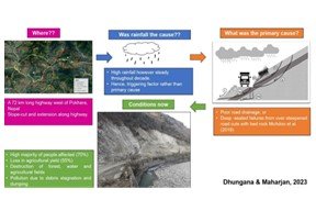
The study addresses the ramifications of development initiatives in delicate mountainous terrains, unveiling significant economic constraints and multifaceted environmental challenges. It focuses on investigating substantial landslides triggered by excavations along a specified stretch of Nepal's Pokhara-Baglung Highway. This research holds significance for policymakers engaged in devising highway development strategies that mitigate future landslides, minimizing both costs and the toll on life and assets. The investigation encompassed on-site cataloging of landslides, lab test of sampled soils and a structured questionnaire distributed among local residents. This comprehensive approach facilitated a thorough assessment of landslide occurrences and their consequential effects. The identified landslides exhibited a consistent rotational pattern, characterized by abundant quartzite and phyllite rock formations. The predominant soil composition consisted of fine-to-medium sands, exhibiting a Plasticity Index (PI) range of 0.5 to 3, indicating marginal plasticity. Significantly, a substantial portion (70%) of the populace reported tangible impacts from landslides, with about 32% of affected individuals confirming an average agricultural productivity loss of 4330 kg/km2. Statistical analysis using the Chi-square test indicated a uniform impact across various demographic categories, including gender, education, proximity to the affected site, and social caste. Although fluctuations in the region, the observed temporal precipitation consistency over decades suggests as an accelerating rather than primary causative factor for landslides. Thus, principal causes of slope failures predominantly link to inadequately managed bedrock excavations and suboptimal road drainage systems underscoring the necessity for systematic inquiries into soil stability post-slope incisions. These measures are pivotal in guiding the construction and expansion of road networks within Nepal's Himalayan region.
Downloads
References
Bhat, D. R., & Wakai, A. (2018). Investigation of Creeping Landslides along the Major Highway of Nepal Triggered by the 2015. Proceedings of a Research Symposium on Strong Nonlinear Phenomena of Surface Ground and Their Effects during a Maximum Earthquake, 8–11.
Budhathoki, B. B. (2019). Engineering Geological Investigation and Stability Analysis of Sunkuda Landslide Using Finite Element and Limit Equilibrium Methods. Tribhuvan University.
Bureau, G. E. (2015). Test Method for Liquid Limit, Plastic Limit, and Plasticity Index Geotechnical Test Method (2nd ed., Issue August). Department of Transportation.
Cruden, D. M., & Varnes, D. J. (1996). Landslide types and processes. Special Report - National Research Council, Transportation Research Board, 247(December), 36–75.
Dahal, R. K. (2006). Geology for Technical Students. Bhrikuti Academic Publications.
Dahal, R. K., Hasegawa, S., Masuda, T., & Yamanaka, M. (2006). Roadside Slope Failures in Nepal during Torrential Rainfall and their Mitigation Road construction practice in Nepal. Disaster Mitigation of Debris Flows, Slope Failures and Landslides, 503–514.
Deoja, B., Dhital, M., Thapa, B., & Wagner, A. (1991). Mountain Risk Engineering Handbook, Applications: Part I. In Mountain Risk Engineering Handbook (p. 578). International Centre tor Integrated Mountain Development (ICIMOD).
Devkota, K. C., Regmi, A. D., Pourghasemi, H. R., Yoshida, K., Pradhan, B., Ryu, I. C., Dhital, M. R., & Althuwaynee, O. F. (2013). Landslide susceptibility mapping using certainty factor, index of entropy and logistic regression models in GIS and their comparison at Mugling-Narayanghat road section in Nepal Himalaya. Natural Hazards, 65(1), 135–165, https://doi.org/10.1007/S11069-012-0347-6
DHM. (2021). Rainfall in Nepal 2011-2020.
Dilley, M., Chen, R. S., Deichmann, U., Lerner-Lam, A. L., Arnold, M., Agwe, J., Buys, P., Kjekstad, O., Lyon, B., & Yetman, G. (2005). Natural Disaster Hotspots: A Global Risk Analysis.
Froude, M. J., & Petley, D. N. (2018). Global fatal landslide occurrence from 2004 to 2016. Natural Hazards and Earth System Sciences, 18(8), 2161–2181,
https://doi.org/10.5194/NHESS-18-2161-2018
Geertsema, M., Highland, L., & Vaugeouis, L. (2009). Environmental impact of landslides. Landslides - Disaster Risk Reduction, 1, 589–607, https://doi.org/10.1007/978-3-540-69970-5_31
Geertsema, M., & Pojar, J. J. (2007). Influence of landslides on biophysical diversity - A perspective from British Columbia. Geomorphology, 89(1-2 SPEC. ISS.), 55–69, https://doi.org/10.1016/j.geomorph.2006.07.019
García-Gaines, R. A., & Frankenstein, S. (2015). USCS and the USDA soil classification system: Development of a mapping scheme. UPRM and ERDC Educational and Research Internship Program. Cold Regions Research and Engineering Laboratory (U.S.) & Engineer Research and Development Center (U.S.), pp. 46.
Hasegawa, S., Dahal, R. K., Yamanaka, M., Bhandary, N. P., Yatabe, R., & Inagaki, H. (2009). Causes of large-scale landslides in the Lesser Himalaya of central Nepal. Environmental Geology, 57(6), 1423–1434, https://doi.org/10.1007/s00254-008-1420-z
Hayati, E., Majnounian, B., Abdi, E., Sessions, J., & Makhdoum, M. (2012). An expert-based approach to forest road network planning by combining Delphi and spatial multi-criteria evaluation. Environmental Monitoring and Assessment, 185(2), 1767–1776, https://doi.org/10.1007/S10661-012-2666-1
Hossain, M. S., Islam, M. A., Badhon, F. F., & Imtiaz, T. (2021). Hydrometer Analysis. Properties and Behavior of Soil-Online Lab Manual.
Hungr, O. (2003). Flow Slides and Flows in Granular Soils. Proceedings of International Workshop on Occurrence and Mechanisms of Flows In Natural Slopes and Earth Fill.
Hungr, O., Leroueil, S., & Picarelli, L. (2014). The Varnes classification of landslide types, an update. Landslides, 11(2), 167–194, https://doi.org/10.1007/S10346-013-0436-Y
Khanal, N., & Watanabe, T. (2005). Landslide and debris flow hazards induced by heavy precipitation in Nepal.
McAdoo, B., Quak, M., Gnyawali, K., Adhikari, B., Devkota, S., Rajbhandari, P., & Sudmeier, K. (2018). Brief communication: Roads and landslides in Nepal: How development affects risk. Natural Hazards and Earth System Sciences Discussions, 1979, 1–6, https://doi.org/10.5194/nhess-2017-461
Mertens, K., Jacobs, L., Maes, J., Kabaseke, C., Maertens, M., Poesen, J., Kervyn, M., & Vranken, L. (2016). The direct impact of landslides on household income in tropical regions: A case study from the Rwenzori Mountains in Uganda.
Science of the Total Environment, 550, 1032–1043, https://doi.org/10.1016/j.scitotenv.2016.01.171
Mirus, B. B., Smith, J. B., & Baum, R. L. (2017). Hydrologic Impacts of Landslide Disturbances: Implications for Remobilization and Hazard Persistence. Water Resources Research, 53(10), 8250–8265, https://doi.org/10.1002/2017WR020842
Mondini, A. C., Guzzetti, F., Chang, K. T., Monserrat, O., Martha, T. R., & Manconi, A. (2021). Landslide failures detection and mapping using Synthetic Aperture Radar: Past, present and future. Earth-Science Reviews, 216, 103574. https://doi.org/10.1016/J.EARSCIREV.2021.103574
Nepal, N., Chen, J., Chen, H., Wang, X., & Pangali Sharma, T. P. (2019). Assessment of landslide susceptibility along the Araniko Highway in Poiqu/Bhote Koshi/Sun Koshi Watershed, Nepal Himalaya. Progress in Disaster Science, 3, 100037, https://doi.org/10.1016/j.pdisas.2019.100037
Pandey, H. P. (2017). Analyze the Occurrence of Rainfall-Induced Landslides in a Participatory Way for Mid-Hills of Nepal Himalayas. Advancing Culture of Living with Landslides, 159–167, https://doi.org/10.1007/978-3-319-53483-1_18
Reichenbach, P., Busca, C., Mondini, A. C., & Rossi, M. (2014). The Influence of Land Use Change on Landslide Susceptibility Zonation: The Briga Catchment Test Site (Messina, Italy). Environmental Management, 54(6), 1372–1384, https://doi.org/10.1007/s00267-014-0357-0
Santini, M., Grimaldi, S., Nardi, F., Petroselli, A., & Rulli, M. C. (2009). Pre-processing algorithms and landslide modelling on remotely sensed DEMs. Geomorphology, 113(1–2), 110-125, https://doi.org/10.1016/j.geomorph.2009.03.023
Sari, D. A. P., Innaqa, S., & Safrilah. (2017). Hazard, Vulnerability and Capacity Mapping for Landslides Risk Analysis using Geographic Information System (GIS). IOP Conference Series: Materials Science and Engineering, 209(1). https://doi.org/10.1088/1757-899X/209/1/012106
Sidle, R. C., & Ochiai, H. (2006). Processes, Prediction, and Land Use American Geophysical Union. In American Geophysical Union.
Sidle, R. C., Ziegler, A. D., Negishi, J. N., Nik, A. R., Siew, R., & Turkelboom, F. (2006). Erosion processes in steep terrain - Truths, myths, and uncertainties related to forest management in Southeast Asia. Forest Ecology and Management, 224(1–2), 199–225, https://doi.org/10.1016/j.foreco.2005.12.019
Soller, D. R. (2004). Introduction to Geologic Mapping. McGraw-Hill Yearbook of Science & Technology, 128–130.
Upreti, B. N., & Dhital, M. R. (1996). Landslide Studies and Management in Nepal. In International center for Integrated Mountain Development. International Centre tor Integrated Mountain Development (ICIMOD).
Westen, C. van. (2016). Landslide inventories. In Caribbean Handbook on Risk Management (1st ed., Vol. 1). CDEMA
Downloads
Published
How to Cite
Issue
Section
License
Copyright (c) 2023 Agriculture and Environmental Science Academy

This work is licensed under a Creative Commons Attribution-NonCommercial 4.0 International License.