Urban heat island relation with land use land cover change in Hetauda sub-metropolitan city of Nepal
Abstract
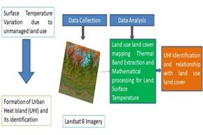
Urban areas are expanding globally at the expense of natural productive land which affects the quality of life of urban residents. Hetauda sub-metropolitan city of Nepal has been undergoing rapid urban growth for the last few decades causing local climatic effects such as land surface temperature (LST) variation. Thus, exploring spatio-temporal changes in land use, land cover (LULC), and urban heat island (UHI) analysis could be an effective means of exposing local environmental issues caused by anthropogenic activities. Development in thermal Remote Sensing and Geographic Information System (GIS) has enabled the monitoring of spatial LST, UHI, and its correlation to LULC. We used Landsat 8 OLI/TIRS satellite data and a supervised classification algorithm for land use land classification for the years 1995, 2008, and 2018 in Arc map software. The spatial pattern of LST was obtained through mathematical calculation of the thermal band of Landsat images. Correlation analysis was applied to explore the relationship between LST, LULC types, and LUCL indices. The LST was higher for urban/built-up and cultivated land use types. There was approximately 4°C mean LST variation for all three years of study. The regression analysis showed a positive correlation of urban/built-up with the Normal Difference Built-Up Index (NDBI) however a negative correlation with the Normal Difference Vegetation Index (NDVI) which implies that green structure weakens the UHI effects while urban/built-up areas strengthen the UHI. Overall, the study can be useful for urban planners in sustainable urban planning and management as well as to raise public awareness of climate change and the warming effect.
Keywords:
GIS, NDVI, NDBI, Remote sensing, Spatio-temporalDownloads
References
Agam, N., Kustas, W. P., Anderson, M. C., Li, F., & Neale, C. M. U. (2007). A vegetation index based technique for spatial sharpening of thermal imagery. Remote Sensing of Environment, 107(4), 545–558.
Agrawal, Y. C., Whitmire, A., Mikkelsen, O. A., & Pottsmith, H. C. (2008). Light scattering by random shaped particles and consequences on measuring suspended sediments by laser diffraction. Journal of Geophysical Research: Oceans, 113(C4).
Barsi, J. A., Lee, K., Kvaran, G., Markham, B. L., & Pedelty, J. A. (2014). The spectral response of the Landsat-8 operational land imager. Remote Sensing, 6(10), 10232–10251.
Bhatti, S. S., & Tripathi, N. K. (2014). Built-up area extraction using Landsat 8 OLI imagery. GIScience & Remote Sensing, 51(4), 445–467.
Bhuyan, M. D. I., Science, M. B., Islam, J., Science, M. B., & Wahid, C. (2013). Characteristics of Summer Monsoon Rainfall over South Asia Using TRMM Data. July.
CBS. (2011). Nepal - Population and Housing Census 2011. https://catalog.ihsn.org/catalog/4210
CBS. (2021). National Census 2021. https://web.archive.org/web/20220127132634/https://censusnepal.cbs.gov.np/
Clinton, N., & Gong, P. (2013). MODIS detected surface urban heat islands and sinks: Global locations and controls. Remote Sensing of Environment, 134, 294–304.
Congalton, R. G. (2001). Accuracy assessment and validation of remotely sensed and other spatial information. International Journal of Wildland Fire, 10(4), 321–328.
DFRS. (2015). State of Nepal ’ S Forests (Issue December). https://doi.org/978-9937-8896-3-6
Eckert, S., Hüsler, F., Liniger, H., & Hodel, E. (2015). Trend analysis of MODIS NDVI time series for detecting land degradation and regeneration in Mongolia. Journal of Arid Environments, 113, 16–28.
Fernández, A., Illera, P., & Casanova, J. L. (1997). Automatic mapping of surfaces affected by forest fires in Spain using AVHRR NDVI composite image data. Remote Sensing of Environment, 60(2), 153–162.
Gao, B. C. (1995). Normalized difference water index for remote sensing of vegetation liquid water from space. Imaging Spectrometry, 2480, 225–236.
Ghosh, J., & Porchelvan, P. (2018). Relationship between surface temperature and land cover types using thermal infrared band and NDVI for Vellore District, Tamilnadu, India. Nature Environment and Pollution Technology, 17(2), 611–617.
Gillespie, T. W., Ostermann-Kelm, S., Dong, C., Willis, K. S., Okin, G. S., & MacDonald, G. M. (2018). Monitoring changes of NDVI in protected areas of southern California. Ecological Indicators, 88, 485–494.
Grigoraș, G., & Urițescu, B. (2019). Land use/land cover changes dynamics and their effects on surface urban heat island in Bucharest, Romania. International Journal of Applied Earth Observation and Geoinformation, 80, 115–126.
Haylemariyam, M. B. (2018). Detection of land surface temperature in relation to land use land cover change: Dire Dawa City, Ethiopia. J Remote Sens Gis, 7(3), 245.
Heinl, M., Hammerle, A., Tappeiner, U., & Leitinger, G. (2015). Determinants of urban–rural land surface temperature differences – A landscape scale perspective. Landscape and Urban Planning, 134, 33–42. https://doi.org/10.1016/J.LANDURBPLAN.2014.10.003
Hokao, K., Phonekeo, V., & Srivanit, M. (2012). Assessing the impact of urbanization on urban thermal environment: A case study of Bangkok Metropolitan. International Journal of Applied, 2(7).
Jamei, Y., Rajagopalan, P., & Sun, Q. C. (2019). Spatial structure of surface urban heat island and its relationship with vegetation and built-up areas in Melbourne, Australia. Science of the Total Environment, 659, 1335–1351.
Jiang, J., & Tian, G. (2010). Analysis of the impact of land use/land cover change on land surface temperature with remote sensing. Procedia Environmental Sciences, 2, 571-575.
Kaplan, G., Avdan, U., & Avdan, Z. Y. (2018). Urban heat island analysis using the landsat 8 satellite data: A case study in Skopje, Macedonia. Multidisciplinary Digital Publishing Institute Proceedings, 2(7), 358.
Laosuwan, T., & Sangpradit, S. (2012). Urban heat island monitoring and analysis by using integration of satellite data and knowledge based method. International Journal of Development and Sustainability, 1(2), 99–110.
Li, B., Wang, W., Bai, L., Wang, W., & Chen, N. (2018). Effects of spatio-temporal landscape patterns on land surface temperature: a case study of Xi’an city, China. Environmental Monitoring and Assessment, 190, 1–11.
Li, W., Saphores, J.-D. M., & Gillespie, T. W. (2015). A comparison of the economic benefits of urban green spaces estimated with NDVI and with high-resolution land cover data. Landscape and Urban Planning, 133, 105–117.
Ma, Y., Kuang, Y., & Huang, N. (2010). Coupling urbanization analyses for studying urban thermal environment and its interplay with biophysical parameters based on TM/ETM+ imagery. International Journal of Applied Earth Observation and Geoinformation, 12(2), 110–118.
Muzzini, E., & Aparicio, G. (2013). Urban growth and spatial transition in Nepal: An initial assessment. World Bank Publications.
Nuruzzaman, M. (2015). Urban heat island: causes, effects and mitigation measures-a review. International Journal of Environmental Monitoring and Analysis, 3(2), 67–73.
Rajeshwari, A., & Mani, N. D. (2014). Estimation of land surface temperature of Dindigul district using Landsat 8 data. International Journal of Research in Engineering and Technology, 3(5), 122–126.
Ranagalage, M., Estoque, R. C., Handayani, H. H., Zhang, X., Morimoto, T., Tadono, T., & Murayama, Y. (2018). Relation between urban volume and land surface temperature: A comparative study of planned and traditional cities in Japan. Sustainability, 10(7), 2366.
Ranagalage, M., Estoque, R. C., & Murayama, Y. (2017). An urban heat island study of the Colombo metropolitan area, Sri Lanka, based on Landsat data (1997–2017). ISPRS International Journal of Geo-Information, 6(7), 189.
Rimal, B., Zhang, L., Keshtkar, H., Haack, B. N., Rijal, S., & Zhang, P. (2018). Land use/land cover dynamics and modeling of urban land expansion by the integration of cellular automata and markov chain. ISPRS International Journal of Geo-Information, 7(4), 154.
Rouse, J. W., Haas, R. H., Schell, J. A., & Deering, D. W. (1974). Monitoring vegetation systems in the Great Plains with ERTS. NASA Spec. Publ, 351(1), 309.
Rousta, I., Sarif, M. O., Gupta, R. D., Olafsson, H., Ranagalage, M., Murayama, Y., Zhang, H., & Mushore, T. D. (2018). Spatiotemporal analysis of land use/land cover and its effects on surface urban heat island using Landsat data: A case study of Metropolitan City Tehran (1988–2018). Sustainability, 10(12), 4433.
Sahana, M., Ahmed, R., & Sajjad, H. (2016) Analyzing land surface temperature distribution in response to land use/land cover change using split window algorithm and spectral radiance model in Sundarban Biosphere Reserve, India. Modeling Earth Systems and Environment, 2: 81.
Santos, M., & Gerry, C. (2017). The shared space: The two circuits of the urban economy in underdeveloped countries. Routledge.
Sarif, M. O., Rimal, B., & Stork, N. E. (2020). Assessment of changes in land use/land cover and land surface temperatures and their impact on surface urban heat island phenomena in the Kathmandu Valley (1988–2018). ISPRS International Journal of Geo-Information, 9(12), 726.
Sharma, R., Chakraborty, A., & Joshi, P. K. (2015). Geospatial quantification and analysis of environmental changes in urbanizing city of Kolkata (India). Environmental Monitoring and Assessment, 187, 1–12.
Shukla, P. R., Skeg, J., Buendia, E. C., Masson-Delmotte, V., Pörtner, H.-O., Roberts, D. C., Zhai, P., Slade, R., Connors, S., & Van Diemen, S. (2019). Climate Change and Land: an IPCC special report on climate change, desertification, land degradation, sustainable land management, food security, and greenhouse gas fluxes in terrestrial ecosystems.
Singh, P., Kikon, N., & Verma, P. (2017). Impact of land use change and urbanization on urban heat island in Lucknow city, Central India. A remote sensing based estimate. Sustainable Cities and Society, 32, 100–114.
Stewart, I. D., & Oke, T. R. (2012). Local climate zones for urban temperature studies. Bulletin of the American Meteorological Society, 93(12), 1879–1900.
Tafesse, B., & Suryabhagavan, K. V. (2019). Systematic modeling of impacts of land-use and land-cover changes on land surface temperature in Adama Zuria District, Ethiopia. Modeling Earth Systems and Environment, 5, 805–817.
Tali, J.A., Divya, S., Murthy, K. (2013) Influence of urbanisation on the land use change: A case study of Srinagar City. American Journal of Research Communication, 1: 271-283.
Tariq, A., Mumtaz, F., Majeed, M., & Zeng, X. (2023). Spatio-temporal assessment of land use land cover based on trajectories and cellular automata Markov modelling and its impact on land surface temperature of Lahore district Pakistan. Environmental Monitoring and Assessment, 195(1), 114.
Tariq, A., Riaz, I., Ahmad, Z., Yang, B., Amin, M., Kausar, R., Andleeb, S., Farooqi, M. A., & Rafiq, M. (2020). Land surface temperature relation with normalized satellite indices for the estimation of spatio-temporal trends in temperature among various land use land cover classes of an arid Potohar region using Landsat data. Environmental Earth Sciences, 79, 1–15.
Tempfli, K., Huurneman, Gc., Bakker, Wh., Janssen, L. L. F., Feringa, W. F., Gieske, A. S. M., Grabmaier, K. A., Hecker, C. A., Horn, J. A., & Kerle, N. (2009). Principles of remote sensing: an introductory textbook. International Institute for Geo-Information Science and Earth Observation.
Thapa, R. B., & Murayama, Y. (2009). Examining spatiotemporal urbanization patterns in Kathmandu Valley, Nepal: Remote sensing and spatial metrics approaches. Remote Sensing, 1(3), 534–556.
Townshend, J. (2001). Landsat Imagery in Geography. International Encyclopedia of the Social & Behavioral Sciences, 8265–8270. https://doi.org/10.1016/B0-08-043076-7/02527-4
United Nations. (2018). World Urbanization Prospects - Population Division - United Nations. https://population.un.org/wup/
United Nations, (2007). World urbanization prospects.
West, H., Quinn, N., Horswell, M., & White, P. (2018). Performance of Sentinel-2 NDVI for assessing the relationship between vegetation and soil moisture under extreme drought conditions. https://uwe-repository.worktribe.com/output/869693/performance-of-sentinel-2-ndvi-for-assessing-the-relationship-between-vegetation-and-soil-moisture-under-extreme-drought-conditions
Wu, C. (2004). Normalized spectral mixture analysis for monitoring urban composition using ETM+ imagery. Remote Sensing of Environment, 93(4), 480–492.
Xiong, L., Deng, Q., Tucker, G. J., McDowell, D. L., & Chen, Y. (2012). Coarse-grained atomistic simulations of dislocations in Al, Ni and Cu crystals. International Journal of Plasticity, 38, 86–101.
Xu, W., Gu, S., Zhao, X., Xiao, J., Tang, Y., Fang, J., Zhang, J., & Jiang, S. (2011). High positive correlation between soil temperature and NDVI from 1982 to 2006 in alpine meadow of the Three-River Source Region on the Qinghai-Tibetan Plateau. International Journal of Applied Earth Observation and Geoinformation, 13(4), 528–535.
Zha, Y., Gao, J., & Ni, S. (2003). Use of normalized difference built-up index in automatically mapping urban areas from TM imagery. International Journal of Remote Sensing, 24(3), 583–594. https://doi.org/10.1080/01431160304987

Published
How to Cite
Issue
Section
Copyright (c) 2024 Agriculture and Environmental Science Academy

This work is licensed under a Creative Commons Attribution-NonCommercial 4.0 International License.

