Comparing Sentinel-2 vegetation indices for optimal estimation of aboveground carbon stock in a tropical community forest of Nepal
DOI:
https://doi.org/10.26832/24566632.2025.1004015Keywords:
Aboveground biomass, Carbon stock, Community forest, Red edge, Tropical forest, Vegetation indicesAbstract
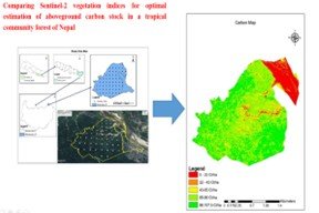
Accurate monitoring of forest carbon stocks is essential for effective climate change mitigation. This study aimed to identify the optimal Sentinel-2 vegetation index (VI) for estimating aboveground carbon (AGC) stock in the Raktamala Namuna Community Forest, Nepal. Field data from 53 circular plots (500 m² each) were used to compute AGC based on tree-level dendrometric measurements and species-specific wood density. Ten VIs, including traditional (e.g., NDVI, EVI) and red-edge-based indices (NDVIre1–NDVIre4), were derived from a cloud-free Sentinel-2 Level-2A image (April 7, 2023). Five regression models (linear, logarithmic, quadratic, power, and exponential) were tested for each VI–AGC relationship. The average AGC was 63.88 t·ha-¹. The red-edge index NDVIre1 (using Band 5, 705 nm), modelled with a logarithmic function, yielded the highest predictive accuracy (R² = 0.7205, r = 0.848, p < 0.001), outperforming traditional indices like NDVI (R² = 0.609). This study demonstrates the superior sensitivity of Sentinel-2’s red-edge band (705 nm) to canopy structure in dense tropical forests. The study concluded that the NDVIre1 logarithmic model provides a novel, cost effective tool for operational and scalable carbon monitoring in community-managed forests, directly supporting REDD+ implementation and localized forest management.
Downloads
References
Chave, J., Andalo, C., Brown, S., Cairns, M. A., Chambers, J. Q., Eamus, D., Fölster, H., Fromard, F., Higuchi, N., Kira, T., Lescure, J. P., Nelson, B. W., Ogawa, H., Puig, H., Riéra, B., & Yamakura, T. (2005). Tree allometry and improved estimation of carbon stocks and balance in tropical forests. Oecologia, 145(1), 87–99. https://doi.org/10.1007/s00442-005-0100-x
Chen, J. M. (1996). Evaluation of vegetation indices and a modified simple ratio for boreal applications. Canadian Journal of Remote Sensing, 22(3), 229–242. https://doi.org/10.1080/07038992.1996.10855178
Delegido, J., Verrelst, J., Alonso, L., & Moreno, J. (2011). Evaluation of Sentinel-2 red-edge bands for empirical estimation of green LAI and chlorophyll content. Sensors, 11(7), 7063–7081. https://doi.org/10.3390/s110707063
Fernández-Manso, A., Fernández-Manso, O., & Quintano, C. (2016). SENTINEL-2A red-edge spectral indices suitability for discriminating burn severity. International Journal of Applied Earth Observation and Geoinformation, 50, 170–175. https://doi.org/10.1016/j.jag.2016.03.005
FRA/NFI, Forest Resource Assessment Nepal. (2015). State of Nepal’s forests. Department of Forest Research and Survey.
Gautam, B., Mandal, R. A., & Badal, D. (2021). Forest carbon dynamic according to altitudinal gradient in Nepal [Unpublished report]. Institute of Forestry.
Gitelson, A. A., Kaufman, Y. J., & Merzlyak, M. N. (1996). Use of a green channel in remote sensing of global vegetation from EOS-MODIS. Remote Sensing of Environment, 58(3), 289–298. https://doi.org/10.1016/S0034-4257(96)00072-7
Gitelson, A. A., & Merzlyak, M. N. (1994). Spectral reflectance changes associated with autumn senescence of Aesculus hippocastanum L. and Acer platanoides L. leaves. Spectral features and relation to chlorophyll estimation. Journal of Plant Physiology, 143(3), 286–292. https://doi.org/10.1016/S0176-1617(11)81633-0
Gómez, M. (2017). Joint use of Sentinel-1 and Sentinel-2 for land cover classification: A machine learning approach [Master's thesis, Lund University]. https://lup.lub.lu.se/student-papers/search/publication/8915043
Huete, A., Didan, K., Miura, T., Rodriguez, E. P., Gao, X., & Ferreira, L. G. (2002). Overview of the radiometric and biophysical performance of the MODIS vegetation indices. Remote Sensing of Environment, 83(1–2), 195–213. https://doi.org/10.1016/S0034-4257(02)00096-2
IPCC, Intergovernmental Panel on Climate Change. (2006). 2006 IPCC guidelines for national greenhouse gas inventories. Institute for Global Environmental Strategies. https://www.ipcc-nggip.iges.or.jp/public/2006
Joshi, R., Singh, H., Chhetri, R., & Yadav, K. (2020). Assessment of carbon sequestration potential in degraded and non-degraded community forests in Terai region of Nepal. Journal of Forest and Environmental Science, 36(2), 113–121. https://doi.org/10.7747/JFES.2020.36.2.113
Khan, K., Iqbal, J., Ali, A., & Khan, S. N. (2020). Assessment of Sentinel-2-derived vegetation indices for the estimation of above-ground biomass/carbon stock, temporal deforestation and carbon emissions estimation in the moist temperate forests of Pakistan. Applied Ecology and Environmental Research, 18(1), 783–815. https://doi.org/10.15666/aeer/1801_783815
Kross, A., McNairn, H., Lapen, D., Sunohara, M., & Champagne, C. (2015). Assessment of RapidEye vegetation indices for estimation of leaf area index and biomass in corn and soybean crops. International Journal of Applied Earth Observation and Geoinformation, 34, 235–248. https://doi.org/10.1016/j.jag.2014.08.002
Kumar, L., & Mutanga, O. (2017). Remote sensing of above-ground biomass. Remote Sensing, 9(9), 935. https://doi.org/10.3390/rs9090935
Laar, A. V., & Akça, A. (2007). Forest mensuration (Vol. 13). Springer. https://doi.org/10.1007/978-1-4020-5991-9
Muhe, S., & Argaw, M. (2022). Estimation of above-ground biomass in tropical afro-montane forest using Sentinel-2 derived indices. Environmental Systems Research, 11(1), 5. https://doi.org/10.1186/s40068-022-00250-y
Padilla, F. M., Peña-Fleitas, M. T., Gallardo, M., & Thompson, R. B. (2017). Determination of sufficiency values of canopy reflectance vegetation indices for maximum growth and yield of cucumber. European Journal of Agronomy, 84, 1–15. https://doi.org/10.1016/j.eja.2016.12.008
Pandit, S., Tsuyuki, S., & Dube, T. (2018). Estimating above-ground biomass in subtropical buffer zone community forests, Nepal, using Sentinel 2 data. Remote Sensing, 10(4), 601. https://doi.org/10.3390/rs10040601
Pearson, R. L., & Miller, L. D. (1972). Remote mapping of standing crop biomass for estimation of the productivity of the short-grass prairie. In Proceedings of the 8th International Symposium on Remote Sensing of Environment (pp. 1357–1381). Environmental Research Institute of Michigan.
Poudel, A., Shrestha, H. L., Mahat, N., Sharma, G., Aryal, S., Kalakheti, R., & Lamsal, B. (2023). Modeling and mapping of aboveground biomass and carbon stock using Sentinel-2 imagery in Chure region, Nepal. International Journal of Forestry Research, 2023, 5553957. https://doi.org/10.1155/2023/5553957
Ravindranath, N. H., & Ostwald, M. (2008). Remote sensing and GIS techniques for terrestrial carbon inventory. In Carbon inventory methods: Handbook for greenhouse gas inventory, carbon mitigation and round wood production projects (pp. 181–199). Springer. https://doi.org/10.1007/978-1-4020-6547-7_14
Roujean, J. L., & Breon, F. M. (1995). Estimating PAR absorbed by vegetation from bidirectional reflectance measurements. Remote Sensing of Environment, 51(3), 375–384. https://doi.org/10.1016/0034-4257(94)00114-3
Rouse, J. W., Jr., Haas, R. H., Schell, J. A., & Deering, D. W. (1974). Monitoring vegetation systems in the Great Plains with ERTS. In Third ERTS-1 Symposium (Vol. 1, Sect. A). NASA, Goddard Space Flight Centre.
Downloads
Published
How to Cite
Issue
Section
License
Copyright (c) 2025 Agriculture and Environmental Science Academy

This work is licensed under a Creative Commons Attribution-NonCommercial 4.0 International License.